
Parks Canada quietly released more details about the Icefields Trail project last week, including a map where the proposed trail could be built.
The controversial project envisions building a paved bike trail from Jasper to Wilcox Campground, near the Columbia Icefield.
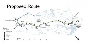
The majority of the 109-kilometre trail will parallel Highway 93 and use existing trails, portions of the old road, and existing bridges where possible.
According to a 17-page document found online, 95 per cent of the trail will remain within an area zoned for outdoor recreation that extends 100 metres on both sides of the highway.
However, the proposed bike trail will deviate from the zoned area near Beauty Flats following the old paved road for about 10 km to Tangle Hill.
According to the map, the trail will cross the highway at least five times.
The new information comes as Parks Canada prepares to hold public consultations about the project in Jasper, Edmonton, Calgary and Banff.
The first public meeting will take place in Jasper on March 14 in conjunction with the Park’s annual public forum at the Sawridge Inn and Conference Centre. The meeting begins at 7 p.m. Feedback can also be submitted online.
According to the proposed layout, the paved trail will be three metres wide and remain between 10-20 metres away from the edge of the road. The trail will also be built for speeds up to 30 km/h and include 40-metre sight lines. It is expected to be completed by March 2019.
According to Parks Canada, over the next two months the agency will be consulting with indigenous stakeholders as well as the public before drafting a direction impact analysis (DIA), also known as an environmental assessment.
From mid-July to mid-August, the draft version of the DIA will be available for review and by September a decision will be made.
The Liberal government unexpectedly announced the project in March 2016, when it earmarked $65.9 million in the federal budget.
In June, five environmental groups voiced their opposition to the project citing a lack of public input. The groups said they feared a paved trail would damage critical habitat for endangered species, such as grizzly bears and woodland caribou.
Six months later, in January, the estimated price tag for the project jumped to $86.4 million. Parks Canada said it would cover the addition $20.5 million from its infrastructure investment program.
Following that announcement, the Canadian Parks and Wilderness Society (CPAWS) called on Catherine McKenna, the minister of environment and climate change, to reject the project.
The proposed trail could eventually be extended to Lake Louise, however no decisions have been made.
Paul Clarke
[email protected]