
 With rising global temperatures, the future of the Athabasca Glacier is in jeopardy, but thanks to Google and it’s mapping capabilities, the glacier will never be forgotten.
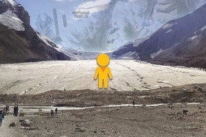
Using its Google Trekker technology—a 360 degree camera mounted on a backpack—Google Canada launched a panoramic “street” view of the glacier on May 26 that brings viewers on a virtual tour along the Sunwapta River until they reach the base of the glacier.
“You can now virtually go right up the glacier itself and see this amazing part of Canada’s geography,” said Aaron Brindle, Google Canada’s mapping expert.
The Athabasca Glacier—one of six toes of the expansive Columbia Icefield—has been slowly shrinking for about 150 years, losing more than five metres of ice each year.
For Brindle, that’s one of the reasons why this project is so powerful.
“Part of what makes this glacier so interesting is you really feel like you might be seeing a piece of history, as the glacier is rapidly receding.”
To photograph the glacier, Google used its Google Trekker—a camera worn as a backpack to capture images in locations only accessible by foot. Operated by an Android device, the Trekker is a globe-like sphere that consists of 15 lenses on top of a mast. Each lens is angled in a different direction that enables Google to stitch together a 360-degree panoramic view.
In addition to the lenses, the trekker is also equipped with an accelerometer and a gyroscope so when the cameras fire they are perpendicular to the ground and can collect high quality images, explained Brindle.
The images are then stored on a disk and sent to Google’s headquarters in Mountain View, Cali., where the images are stitched together.
Google took the photos of the glacier last summer and only recently made them available online, said Peter Lemieux, the lead guide for Athabasca Glacier Icewalks. Lemieux accompanied Brindle when he gathered images of the glacier.
“I would hope that this will encourage people to come to see it for themselves,” he said.
“Fifty years from now you’re really going to want to see what it used to be like, because the changes that have taken place even in the 30 years that I’ve seen is breathtaking,” said Lemieux, who started as a guide in 1985.
Mapping the Athabasca Glacier is part of a larger project by Google Canada to digitally map remote areas and communities across Canada.
“I think we take it for granted in some of the larger communities in Canada that our maps are accurate, but it’s certainly not the case in many places, like Iqaluit, Churchill or Cambridge Bay,” said Brindle, referring to remote northern communities in Nunavut and Manitoba.
“One of the things I love about digital cartography and street view imagery, as a part of that, is this capacity to reflect back to us who we are and our geography.”
He admitted it’s an ambitious task to map all of Canada, but said it’s worth doing.
“These ambitions are what drive us. Who would have thought that we’d actually have street view imagery of every urban centre in Canada, the U.S. and most cities in Europe? Why not think big?”
Paul Clarke
[email protected]